Identity area
Reference code
PL OPiP IV-1-2-428
Title
Śródmieście - obiekty zabytkowe
Date(s)
- 1956 (Creation)
Level of description
Item
Extent and medium
dwustronny, druk barwny, składany
Context area
Name of creator
Biographical history
Name of creator
Biographical history
Repository
Content and structure area
Scope and content
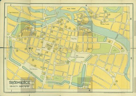
Plan wrocławskiego śródmieścia, ograniczonego od zachodu i południa ulicą Podwale, od wschodu zakolem Odry, od północy starorzeczem Odry w Ogrodzie Botanicznym i prawym brzegiem rzeki; na planie zaznaczono kolejnymi numerami 68 punktów, opisanych na odwrocie jako poszczególne wrocławskie zabytki; plan tworzy integralną całość ze Schematycznym planem miasta Wrocławia (w opracowaniu OPiP), na co wskazuje opisanie siatki literami J i K oraz numerami 8 i 9, mającymi odniesienie do ww. Schematycznego planu...
Accruals
System of arrangement
Conditions of access and use area
Conditions governing access
Brak ograniczeń
Conditions governing reproduction
Language of material
- Polish
Script of material
Language and script notes
pl
Finding aids
Existence and location of originals
Existence and location of copies
Related units of description
Alternative identifier(s)
Dawna sygnatura
AZO-DF-428
Access points
Subject access points
Place access points
Name access points
Genre access points
Digital object metadata
Access
Restricted